
Sushi, geisha, sumo – everyone knows at least a few famous things from Japan. But how many people actually know what the country looks like on a map?
Our Japanese writer asked six of his foreign friends with an interest in Japan to draw a map of the country to see just how good their knowledge of the country was. The following collection of decidedly poopy-looking doodles is what he got back.
Drawing a map of any foreign country without peeking at an atlas or quickly tapping the country’s name into Google can be tricky at the best of times, and so our writer doubted whether his friends–who hail from Hong Kong, America, Thailand, England, Denmark and Vietnam–would be able to draw a map of Japan accurately.
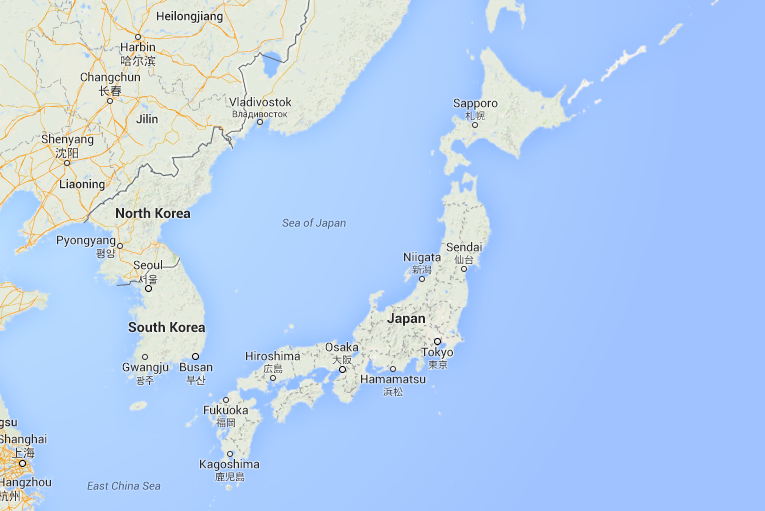
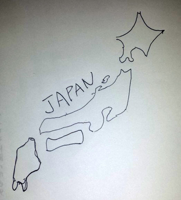
The main problem with the drawings our writer received from his friends is that none of them seemed to be aware that Japan is actually made up of four distinct islands (as well as thousands more tiny ones and Okinawa in the far south). There’s Hokkaido in the north, then the largest and most popular island Honshu, then Shikoku and Kyushu in the south.
For reference, here’s what Japan actually looks like:
Now let’s take a look at our foreign doodlers’ efforts!
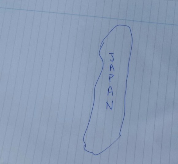
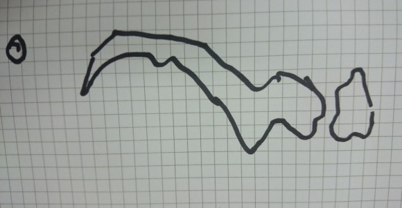
First up is Kalvin from Hong Kong. Japanese cars and electronics are really popular in Hong Kong, and it’s not actually that far away, so we had high hopes for this one. Unfortunately, what we got back was basically a long, turd-shaped thing that, without “JAPAN” written down its length, we would never recognized.
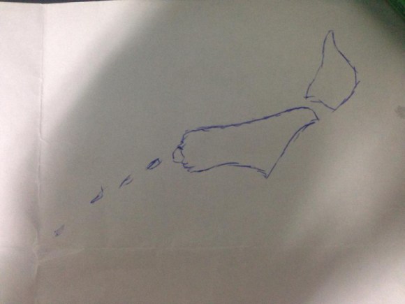
The next drawing is from R-san, an American who simply adores Dragon Ball. R’s a pretty smart guy, so we were expecting something special but…we got another weird sausage shape! And this time it came with some mysterious dots, like a fly had stepped in an ink pot then hopped all over this work of art.
The below drawing is from P-san, who hails from Thailand. Although Hokkaido and Honshu are shown as connected, and there’s a weird fish-tail thing going on at the bottom, this is actually pretty good. The general outline’s there, and there’s even some katakana and the Japanese flag, so we’re definitely giving extra points for that effort.
This one is from Mr. C, who is English. It gets a passing mark since Hokkaido and Honshu are shown as separate islands, and there’s something at the bottom that could potentially be Okinawa and its surrounding islands, but it still looks a bit like a Yorkshire Terrier pooping.
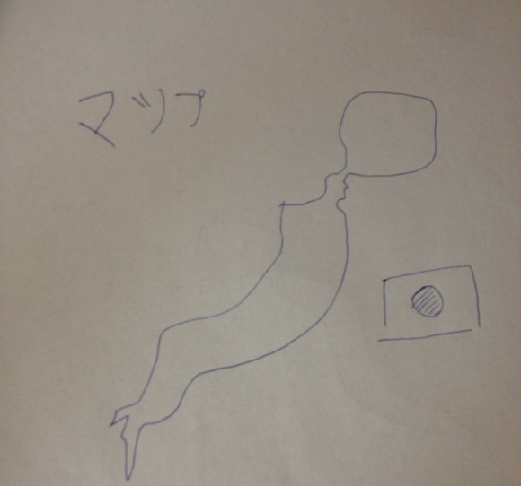
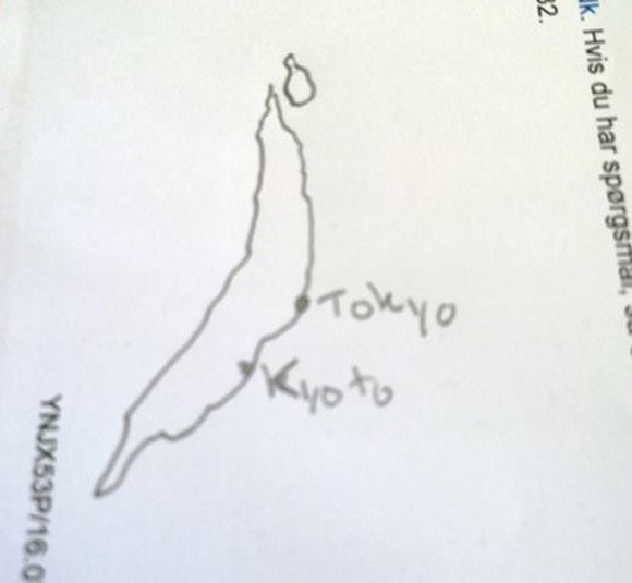
U-san from Denmark included some helpful labels on his own poop-shaped Japan, and we do have Hokkaido and Honshu separate, even if the latter is kind of tiny. However, Shikoku and Kyushu have again been completely forgotten about.
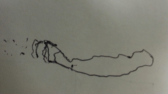
Mr T from Vietnam, meanwhile, also gets a passing mark for having Hokkaido separate and remembering the island of Okinawa off the bottom. We’re not sure why he’s drawn the country horizontally, though. Maybe this is Japan is seen from space or after messing around with Google Maps too long.
And last but not least we have the entry from our own writer, a real live Japanese person. Hokkaido at the top is looking strangely angular, but the four separate island are all there, which is the least we can ask for. Hopefully every Japanese person would produce something of this level minimum. But before our Japanese readers start getting all smug, we’d like to see the kind of maps they’d produce if asked to draw some of the countries listed above!
Who do you think made the best attempt? Let us know in the comments section below!
[ Read in Japanese ]
 Five million yen reward offered to anyone who can find missing dog in Tokyo
 Japan’s new manhole cover T-shirts let you show off your local prefectural pride
 You can go surprisingly far on a single train leaving from Tokyo Station
 Japanese government recommends changing Buddhist temple mark on maps to avoid Nazi connotations
 McDonald’s new Happy Meals offer up cute and practical Sanrio lifestyle goods
 All-you-can-drink Starbucks and amazing views part of Tokyo’s new 170 meter-high sky lounge
 Studio Ghibli glasses cases let anime characters keep an eye on your spectacles
 Super Nintendo World expansion gets delayed for several months at Universal Studios Japan
 Starbucks reopens at Shibuya Scramble Crossing with new look and design concept
 Kyoto’s 100 Demons yokai monster parade returns!
 Hello Kitty/Yu-Gi-Oh crossover Happy Meal toys appear, but far, far away from Japan
 A visit to the best UFO catcher arcade in the universe!
 More foreign tourists than ever before in history visited Japan last month
 Hey, Japanese taxi driver! Take us to your favorite restaurant in Tsuruga City!
 Disney princesses get official manga makeovers for Manga Princess Cafe opening in Tokyo
 Beautiful new Final Fantasy T-shirt collection on the way from Uniqlo【Photos】
 Is the new Shinkansen Train Desk ticket worth it?
 Foreign English teachers in Japan pick their favorite Japanese-language phrases【Survey】
 Japanese convenience store packs a whole bento into an onigiri rice ball
 We try out “Chan Ramen”, an underground type of ramen popular in the ramen community
 Studio Ghibli releases Kiki’s Delivery Service chocolate cake pouches in Japan
 Japan’s bone-breaking and record-breaking roller coaster is permanently shutting down
 New definition of “Japanese whiskey” goes into effect to prevent fakes from fooling overseas buyers
 Our Japanese reporter visits Costco in the U.S., finds super American and very Japanese things
 Studio Ghibli unveils Mother’s Day gift set that captures the love in My Neighbour Totoro
 Foreign passenger shoves conductor on one of the last full runs for Japan’s Thunderbird train
 Domino’s Japan now sells…pizza ears?
 New Japanese KitKat flavour stars Sanrio characters, including Hello Kitty
 Kyoto creates new for-tourist buses to address overtourism with higher prices, faster rides
 Sales of Japan’s most convenient train ticket/shopping payment cards suspended indefinitely
 Sold-out Studio Ghibli desktop humidifiers are back so Totoro can help you through the dry season
 Japanese government to make first change to romanization spelling rules since the 1950s
 Ghibli founders Toshio Suzuki and Hayao Miyazaki contribute to Japanese whisky Totoro label design
 Doraemon found buried at sea as scene from 1993 anime becomes real life【Photos】
 Tokyo’s most famous Starbucks is closed
 One Piece characters’ nationalities revealed, but fans have mixed opinions
 We asked a Uniqlo employee what four things we should buy and their suggestions didn’t disappoint
 Princesses, fruits, and blacksmiths: Study reveals the 30 most unusual family names in Japan
 Survey ranks Japanese prefectures by how much people want to continue living there
 East meets West in the Pacific-centered version of the world map
 How safe is Japan? New interactive map reveals reports of crime around the country
 Studio Ghibli theme park’s opening will not be delayed by coronavirus, planners promise
 What was this Attack on Titan giant doing at a protest in Hong Kong?
 South Korean design company turns subway maps into beautiful artwork you can hang on your wall
 A rice by any other name: Japanese Twitter investigates local terms for “serving”
 Tour alleged yakuza hideouts on Google Maps
 Daiso releases shoulder bag series for every prefecture in Japan with surprising trivia facts
 Japan’s favorite Pokémon types by prefecture–which types are the most popular?
 Tokyo accessory maker turns Japan’s prefectures into pieces of art to wear around your neck
 The ultimate Shinkansen trip: Riding Japan’s bullet train network from one end to the other
 Can you guess the most densely populated city in the world?
 Travel through time with these old maps from the Zenrin Virtual Museum
 Three bridges in Okinawa Prefecture offer the most spectacular panoramic vistas of the sea【Pics】
Leave a Reply