
The Edo Past and Present Wanderings app appeals not only to old map buffs, but to anyone with a sense of adventure.
One of my favorite things to do when I have some spare time is to take a leisurely stroll around the neighborhood. Whether it’s while traveling or in the same city I’ve lived in for years, there’s nothing quite like the thrill of meandering down hidden pathways and immersing myself in the local flavor right around the corner.
For others with the same hobby, we’d like to share a couple of friendly tips. First, no matter how many times you go, there will always be another unknown corner around which to explore new scenery. Today might be that day when you find something amazing that was right under your nose the whole time! Second, if you happen to live in Tokyo, your meandering has just gotten even more exciting with the introduction of a new smartphone and tablet app called Edo Past and Present Wanderings on December 19th. This app should undoubtedly satiate the curiosity of anyone who has ever wondered, “What was my neighborhood like in the olden days of Tokyo?”
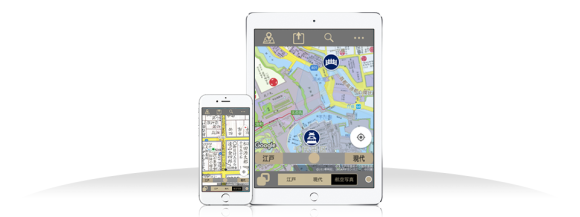
▼ The new app displayed on a smartphone and on a tablet
Edo Past and Present Wanderings features a fully functional map service that can switch between street maps of modern-day Tokyo and maps of the city in the latter years of the Edo period, the era between 1603-1868 which were marked by the Tokugawa Shogunate and isolationism from the rest of the world. It was laboriously developed by five different agencies: East Japan Marketing and Communications, JAF Media Works, Seiei Co., Ltd., BeMap, and Fuji Television, which should give you a hint about the high level of craftsmanship poured into its creation.
▼ Figure 1 demonstrates the app’s ability to overlay old maps with modern ones. 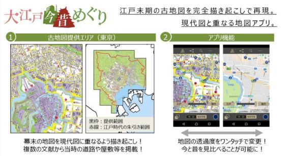
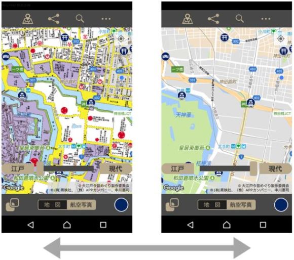
Here’s an enlargement of Figure 2 above. By sliding the gray bar from the left (Edo time) to the right (modern time), you can even adjust the degree of transparency between the maps. By the way, Edo (literally “bay entrance”) was renamed Tokyo (“eastern capital”) when Emperor Meiji moved the capital to there from Kyoto in 1868.
What makes Edo Past and Present Wanderings so special? Similar apps detailing the streets of Edo/Tokyo have previously been released, but they have always come with a few pointed drawbacks, namely being digitized versions of extant maps from the Edo Period which don’t always match nicely with modern terrain and localities. They may also contain handwriting that is difficult to decipher due to its age or outdated writing style. In contrast, the new app utilizes newly rendered images derived directly from Edo-period maps, which were painstakingly traced by experts in a way that could easily overlap with modern maps.The writing has also been converted over to contemporary script for ease of reading, all while maintaining authenticity.
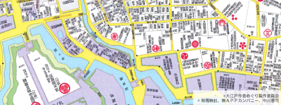
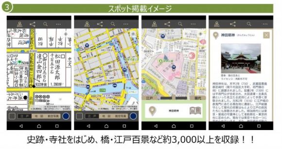
Finally, as shown in the image below, the app also captures approximately 3,000 important landmarks and monuments such as temples and bridges, which makes it even more fun to walk around until you–literally–bump into something interesting!
Edo Past and Present Wanderings for either Apple or Android can be downloaded here. Might we suggest that you only download it when you’re sure to have at least a spare hour on your hands, since you probably won’t want to leave anytime soon once you discover the streets of Edo.
Source: Tokyo IPO
Featured image: EdoMap
Top image: EdoMap
Insert images: Tokyo IPO, EdoMap
 VR and GPS combine for new Japanese castle and historical landmark sightseeing app
 Tokyo’s busiest train stations have a new, free, English-compatible navigation app
 New anime Gate entertains, tries to recruit you to the Japan Self-Defense Forces at the same time
 Smartphone app finds empty restroom stalls in Tokyo subway station, makes pooing easier than ever
 Cute PC character cushions from Japan protect your wrists, keep you company at the same time
 McDonald’s new Happy Meals offer up cute and practical Sanrio lifestyle goods
 More foreign tourists than ever before in history visited Japan last month
 Starbucks reopens at Shibuya Scramble Crossing with new look and design concept
 The oldest tunnel in Japan is believed to be haunted, and strange things happen when we go there
 Arrest proves a common Japanese saying about apologies and police
 “Half-naked men only in loincloths” drum battle returns to Hida festival for first time in five years
 Is the new Shinkansen Train Desk ticket worth it?
 Tokyo’s most famous arcade announces price increase, fans don’t seem to mind at all
 Randomly running into a great sushi lunch like this is one of the best things about eating in Tokyo
 Our reporter takes her 71-year-old mother to a visual kei concert for the first time
 Disney princesses get official manga makeovers for Manga Princess Cafe opening in Tokyo
 We try out “Chan Ramen”, an underground type of ramen popular in the ramen community
 Foreign English teachers in Japan pick their favorite Japanese-language phrases【Survey】
 Beautiful new Final Fantasy T-shirt collection on the way from Uniqlo【Photos】
 There’s a park inside Japan where you can also see Japan inside the park
 New Studio Ghibli bedding sets are cool in all senses of the word
 Japanese convenience store packs a whole bento into an onigiri rice ball
 Hanton rice — a delicious regional food even most Japanese people don’t know about, but more should
 New Pokémon cakes let you eat your way through Pikachu and all the Eevee evolutions
 Hamburg and Hamburg Shibuya: A Japanese restaurant you need to put on your Tokyo itinerary
 Studio Ghibli releases Kiki’s Delivery Service chocolate cake pouches in Japan
 Japan’s bone-breaking and record-breaking roller coaster is permanently shutting down
 New definition of “Japanese whiskey” goes into effect to prevent fakes from fooling overseas buyers
 Foreign passenger shoves conductor on one of the last full runs for Japan’s Thunderbird train
 Our Japanese reporter visits Costco in the U.S., finds super American and very Japanese things
 Kyoto bans tourists from geisha alleys in Gion, with fines for those who don’t follow rules
 Studio Ghibli unveils Mother’s Day gift set that captures the love in My Neighbour Totoro
 Domino’s Japan now sells…pizza ears?
 New Japanese KitKat flavour stars Sanrio characters, including Hello Kitty
 Kyoto creates new for-tourist buses to address overtourism with higher prices, faster rides
 Sales of Japan’s most convenient train ticket/shopping payment cards suspended indefinitely
 Sold-out Studio Ghibli desktop humidifiers are back so Totoro can help you through the dry season
 Japanese government to make first change to romanization spelling rules since the 1950s
 Ghibli founders Toshio Suzuki and Hayao Miyazaki contribute to Japanese whisky Totoro label design
 Doraemon found buried at sea as scene from 1993 anime becomes real life【Photos】
 Tokyo’s most famous Starbucks is closed
 One Piece characters’ nationalities revealed, but fans have mixed opinions
 We asked a Uniqlo employee what four things we should buy and their suggestions didn’t disappoint
 Princesses, fruits, and blacksmiths: Study reveals the 30 most unusual family names in Japan
 Studio Ghibli’s new desktop Howl’s Moving Castle will take your stationery on an adventure
 What the…?!? Stuffed “Teddytaur” toy baffles and fascinates us at the same time
 Struggling with Japanese? Let Tako lend you a hand…or five
 Travel through time with these old maps from the Zenrin Virtual Museum
 Japanese netizens fall in love with groovy augmented reality navigation app 【Video】
 Pokémon GO melds with Tokyo’s traditional neighborhood for Asakusa Routes event, gets thumbs up from us
 Japanese company will pay you to stroll around Tokyo as a literal walking advertisement
 Want to be guided around Tokyo by a ninja? With an upcoming app, now you can!
 Four pieces of important advice for foreigners in Japan moving from the countryside to Tokyo
 Advice for Tokyo 2020 Olympics volunteers: Dress like a Japanese ninja
 What’s it like traversing Tokyo using only wheelchair accessible routes?
 Japanese town’s Cat Street View lets you virtually tour its backstreets, meet feline residents
 Tonight vs Hotel Tonight – Did GREE just rip off one of America’s most popular hotel apps?
 Awesome Japanese light gun uses your smartphone to turn real world into huge first-person shooter
 Catch trendy Pokémon at Harajuku’s Takeshita Street for a limited time
Leave a Reply